Spit to Manly
Sydney’s Classic North Harbour Walk

-
A scenic harbour walk linking bushland tracks, secluded beaches and family-friendly reserves between Middle Harbour and Manly.
Distance: 10 km Time: 3–4 hrs
Steps: c15,000
Level of Difficulty: Moderate (long with many ups and downs) -
Sandy Bay & Clontarf Reserve — café, playground and netted harbour pool
Castle Rock Beach — secluded harbour beach reached by steps
Grotto Point Lighthouse sidetrack & Middle Harbour views
Aboriginal engravings at Grotto Point
Dobroyd Head & Crater Cove lookout panoramas
Reef Beach & Forty Baskets Beach swimming spots
North Harbour & Fairlight Beach rock pool
Manly Wharf and Cove at walk’s end.
The iconic Manly Beach - surfboards and other gear are available for hire from a few places along North Steyne which fronts the beach.
Shelly Beach is not far from Manly Beach and is one of the best snorkel/dive spots in Sydney
-
Parking near the Spit is limited and timed; bus return (144) is easy
Check Spit Bridge opening times to avoid delays before starting
Check tides — some foreshore sections are easier at low tide
Start early for quieter tracks and better parking at the Spit
Limited shade in sections - Sun protection recommended
Dogs not permitted through most of the national park sections
The Spit Bridge to Manly walk is one of Sydney’s best-known and most scenic harbour walks, with sweeping views and plenty of places to swim, picnic and explore along the way. Part of the longer Sydney Harbour Scenic Walkway to North Head, it isn’t technically difficult, but its length and constant ups and downs may make it a challenge for some.
The route threads through pockets of bushland and a string of harbour beaches and reserves, gradually revealing wider coastal views as you get closer to Manly. It’s a walk with real variety — quiet tracks, open headlands and family-friendly swimming spots — and there are plenty of places to eat and drink and put your feet up once you get to Manly.
WALKING THE TRAIL
The Spit Bridge to Clontarf Reserve
This walk can be done in either direction, but most people start at the Spit and finish in Manly with a swim, meal or ferry ride home. The track begins on the north side of the Spit Bridge — cross at the lights on the right, or take the pedestrian underpass on the left to the start of the trail.
A word of warning: The Spit Bridge is a fairly old bridge (built in 1958) and it’s not a very high one. It is what’s known as a bascule bridge and it opens and shuts several times a day to let tall masted boats through, stopping traffic in the process. If you arrive at one of the opening times you’ll be stuck on the South side until it reopens. Not for long, but you can avoid the wait by checking Spit Bridge opening times before starting out.
The first section winds through fern-filled bush in Ellery’s Punt Reserve, where birdsong quickly dampens the traffic noise.

Before long you’ll emerge at Sandy Bay and Clontarf Reserve. This is a popular spot, especially on the weekends. There’s a large playground, an open off-leash area for dogs and a netted one for humans. There’s also the waterside cafe, Sandy Bear, worth a stop if you’re hungry or need a caffeine boost.


Clontarf Reserve to Grotto Point
Leaving the reserve, head along the foreshore, walking to the end of the beach and on into the bush toward Castle Rock Beach. (If the tide is up, you’ll need to walk along Monash Crescent part of the way.)
Castle Rock Beach is one of those idyllic spots, little known and hidden away so if you want to make a stop here for a picnic or a swim, you may find you have it all to yourself. It’s a small beach hemmed in by the harbour and surrounded by bush. A set of steps just off the path will take you down to the sand.
Continuing along the path, look for an unmarked sidetrack to Grotto Point Lighthouse (c1910) and views across Middle Harbour. A rougher branch track leads further down to (clothing optional) Washaway Beach. The water was calm around here when we walked but the surrounding cliffs can be pounded when the swell is up, hence the name.


Back on the main path you’ll soon come to the Grotto Point Engraving site where there are some relatively well-preserved stone etchings of a giant kangaroo, a whale, boomerangs and small fish. The engravings were made by the area’s Aboriginal inhabitants and though they are said to be about 1000 years old their precise age is unknown.
Grotto Point to Dobroyd Head
Walking north from Grotto Point the track leads to Dobroyd Head opening to expansive harbour panoramas that take in Manly, North Head, South Head and the ocean beyond.
From the Crater Cove lookout, see if you can spot the old fishing shacks perched on the cliffs below. Built between 1923 and 1963, they’ve served as weekenders for some over the years and for others as permanent homes, especially during the Great Depression. When the area was declared National Park in 1984 all were evicted, and the huts are now maintained by volunteers.

Fishing Huts on Dobroyd Headland
If you’re thirsty at this point or looking for a loo, Tania Park, just behind the headland has bubblers and toilets and on weekends, a nearby Mr Whippy van sells coffee and ice cream.

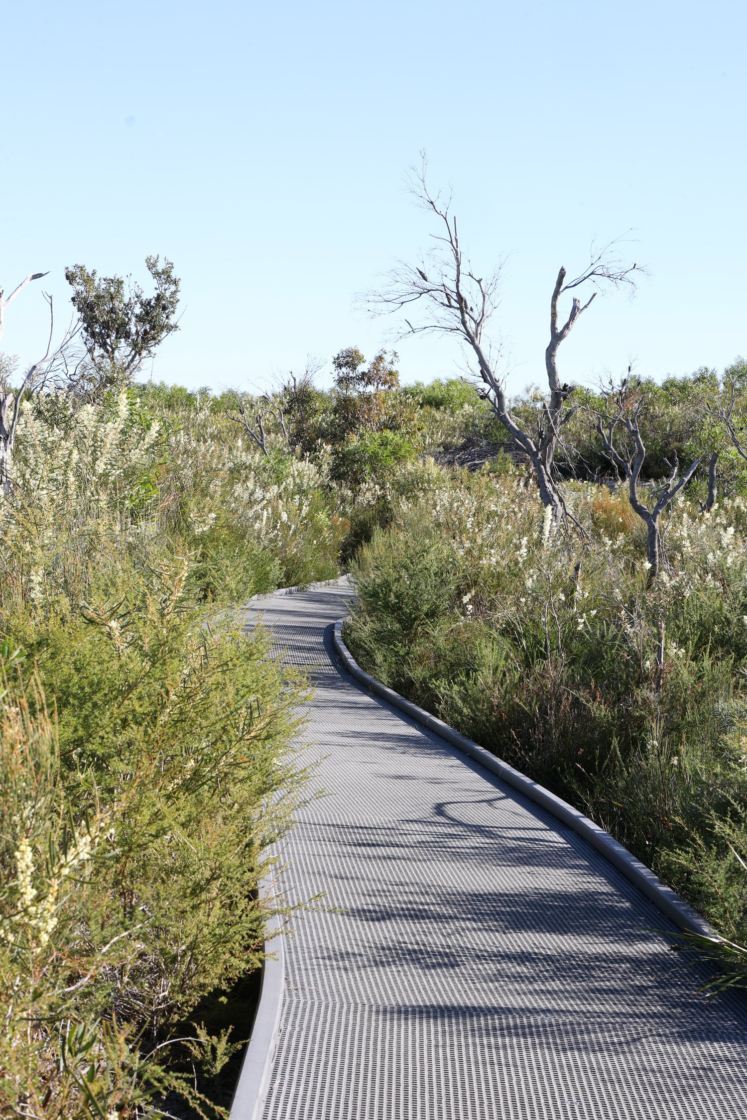

This section of the track is especially picturesque and not only owing to the views. The boardwalks wind through native bushland bright with bottlebrush in winter and colourful wildflowers in the warmer months.
The path then descends through more shaded vegetation toward Reef Bay.
Reef Beach to North Harbour
The next part of the walk takes you past some small protected beaches and picnic spots.
Reef Beach, the first of these, is a small, secluded beach with great views over to Manly. According to National Parks there are Aboriginal carvings in the surrounding rocks so look out for these if you’re walking at low tide.

Next stop along the path is Forty Baskets Beach, a little slice of paradise for the residents that sit above and another pretty place for the rest of us to visit. There’s an enclosed swimming area with jump-off jetty, a swing set, barbecues, tables and toilets.
If you’re walking during a very high tide you may need to take the road to skirt around Forty Baskets and the reserve beyond. But the waterside paths are usually pretty accessible even if your feet might get a little wet.
Around the bend from Forty Baskets lies North Harbour Reserve, with its broad grassy park, popular for picnics and dog-walking. Follow the foreshore path, then take the stairs up to King Avenue. Turn right into Lauderdale Street and about 50 on, take the path down to the water to join the Fairlight Walk.


Fairlight to Manly
This final stretch to Manly offers more of the same - great swimming spots, picnic areas and fabulous views.
Fairlight Beach has a 30 metre long rock pool popular with lap swimmers and families, and clear water suitable for snorkelling.

Fairlight Beach and pool
The pathway from here to Manly is well defined and littered with warnings to keep dogs on leads and to watch out for penguins. A small colony of Little Penguins is known to breed in the area around Esplanade Park though you’re unlikely to see them during the day. They are of course protected and as they are the only remaining breeding colony on the NSW mainland, visitors are strongly discouraged from disturbing them in any way.
Esplanade Park foreshore, Manly
Passing Manly Pavilion and the former aquarium site, the track rounds into Manly Cove and finishes at Manly Wharf, which officially marks the end of the walk.
From here you can get the ferry to the city or the 144 bus back to The Spit. Or, you can take the opportunity to explore Manly and all it has to offer.
In the area
There is plenty to do in Manly if you’ve still got the energy. Indeed if you’re up for it, you can extend your walk another ten kilometres or so, all the way to North Head.
But for everyone else… The adjacent beach offers one option for a swim or if it’s waves you’re after, the iconic Manly Beach is just a five minute walk away.


For a cultural diversion, there’s a small art gallery and museum across from the wharf that regularly exhibits up and coming and established artists. And Manly Markets operates every Saturday and Sunday in the Corso and Sydney Rd.
There are plenty of places to eat and drink in Manly. At the wharf, along The Corso and in the surrounding streets you’ll find restaurants, cafes and pubs catering to all tastes. And if you haven’t yet had enough of those magnificent views I can recommend The Boat House at Manly Pavilion. We went here at the end of our walk and rewarded ourselves with a delicious lunch on the terrace.
LAST UPDATED FEBRUARY 2026